Search
Search Results
-
A new LSTM-based model to determine the atmospheric weighted mean temperature in GNSS PWV retrieval
The atmospheric weighted mean temperature ( T m ) is a key parameter in determining the precipitable water vapor (PWV). Conventional meteorological...
-
Satellite laser ranging to Galileo satellites: symmetry conditions and improved normal point formation strategies
High-precision satellite laser ranging measurements to Galileo retroreflector panels are analyzed to determine the angle of incidence of the laser...

-
An effective automatic processing engine for improving the multi-GNSS constellation precise orbit prediction
Orbit prediction (OP) recently tends to be a very crucial step for supporting real-time GNSS orbit services due to the dynamic stability of...

-
Enabling the Galileo high accuracy service with open-source software: integration of HASlib and RTKLIB
The Galileo high accuracy service (HAS) is a free-of-charge service designed to deliver decimeter-level accuracy in real-time precise point...

-
Utilizing least squares variance component estimation to combine multi-GNSS clock offsets
The International GNSS Service (IGS) provides combined satellite and station clock products, which are generated from the individual clock solutions...

-
Relationship between GIX, SIDX, and ROTI ionospheric indices and GNSS precise positioning results under geomagnetic storms
Ionospheric indices give information about ionospheric perturbations, which may cause absorption, diffraction, refraction, and scattering of radio...

-
Improving GNSS PPP-RTK through global forecast system zenith wet delay augmentation
The precise point positioning real-time kinematic (PPP-RTK) is a high-precision global navigation satellite system (GNSS) positioning technique that...

-
GPS/Galileo/BDS phase bias stream from Wuhan IGS analysis center for real-time PPP ambiguity resolution
While few phase bias streams are available from the IGS Real-time Service Phase, such products are essential to enable PPP ambiguity resolution....
-
Machine learning approach for GNSS geodetic velocity estimation
This study aimed to investigate the performance of machine learning (ML) algorithms in determining horizontal velocity at specific points using the...

-
Analysis of factors influencing significant wave height retrieval and performance improvement in spaceborne GNSS-R
As an emerging observational method, spaceborne global navigation satellite system-reflectometry (GNSS-R) has been applied recently for significant...

-
Estimation of phase center corrections for BDS satellites aligned to the IGS20 frame
Precise information about the phase center corrections (PCCs) for BeiDou satellite antennas is not only essential to the generation of high-precision...

-
On the estimation of scintillation severity using background F-region peak densities: description and example results using GOLD observations
Amplitude scintillations in Global Navigation Satellite System (GNSS) signals are commonly observed at low latitudes and are frequently associated...

-
A LiDAR–INS-aided geometry-based cycle slip resolution for intelligent vehicle in urban environment with long-term satellite signal loss
Intelligent vehicles usually equip with GNSS receivers and MEMS-IMU for localization and light detection and ranging (LiDAR) sensors for perception....

-
Homogeneous PPP–RTK user positioning performance as a consequence of network integer ambiguity resolution
PPP–RTK, a synthesis of precise point positioning (PPP) and real-time kinematic (RTK) techniques, achieves fast integer ambiguity resolution-enabled...

-
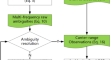
A common-view carrier phase frequency transfer based on PPP-derived parameters
The high-precision time and frequency transfer method, based on the global navigation satellite system (GNSS) precise point positioning (PPP), has...

-
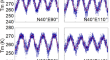
Velocity estimation method for high-spinning vehicle based on a side-mounted single patch antenna
The navigation and velocity measurement methods using GPS (global positioning system) signals based on a side-mounted single patch antenna are key...

-
Global zenith wet delay modeling with surface meteorological data and machine learning
The tropospheric delay is a major error source for space geodetic techniques, and the performance of its modeling is significantly limited due to the...

-
Improving PPP smartphone processing with adaptive quality control method in obstructed environments when carrier-phase measurements are missing
High received signal noise and limited multipath suppression capabilities cannot be neglected when it comes to smartphone-grade GNSS receivers and...

-
Estimation of the water vapor field by fusing GPS and surface meteorological observations on the Loess Plateau of China
Water vapor is one of the important atmospheric components of atmospheric circulation and dynamics, and its accurate and spatiotemporally continuous...
